USFS pushes ‘dependable water’ tool
A new tool from the U.S. Forest Service aims to help land managers and the public understand where their water comes from.
It’s called “Forest to Faucets 2.0” and “shows that forests are a critical link in providing dependable water for drinking across the country,” according to a statement.
“Forests to Faucets is a powerful tool that demonstrates the direct link between Allegheny National Forest and clean water,” Forest Supervisor Jamie Davidson said. “The map shows how water from the forest connects us all, from the Allegheny Scenic and Wild River to Pittsburgh, Pennsylvania and all the communities in between.”
They call it a “story map” that is “designed to increase public and land manager understanding of the relationship between forests and water quality. The map visualizes the role forests have in supplying drinking water across the country, and it can help planners, forestry professionals, watershed groups, educators and others see how forests help protect water quality.”
It also shows how some watersheds are more important than others from a drinking water perspective and assesses threats to water sources such as insects and disease, land-use changes, future decreases in yields and wildfire potential.
The map identifies over 20 watersheds in Warren County. All are scored between an 85 and 100 on a scale of “relative importance” to water resources.
The tool gives characteristics of each watershed, ownership information by percentage and the ability for the watershed to produce clean water.
A score is then assigned to each of those threat areas. Watersheds in the county most had low to moderate insect and disease threat scores. None had identified wildfire threats.
The watershed that encompasses most of the City of Warren scored 98 out of 100 on the “relative land use change threat and “is predicted to have a -6.09% change in mean annual water yield between 2010-2090 under the high emissions climate change scenario.”
“Businesses, organizations, and landowners can use it to identify reliable sources of water, have more information available for planning and to develop grant applications for activities like water conservation and tree planting,” the statement said. “The data can also be used for teaching and learning in geography, environmental studies, biology, hydrology and other disciplines.”
Community
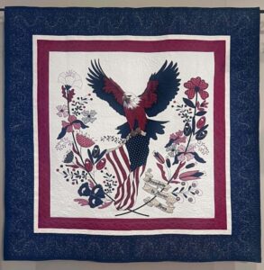
Patriotic quilt contest planned for county
Briefs
Community Blood Bank schedules blood drives The Community Blood Bank will hold two blood drives in Warren County. ...
Warren Public Library to host Bigfoot, Paranormal Kinzua event
Residents interested in local legends and unexplained phenomena will have an opportunity to learn more about both ...
Second Harvest Food Bank partners with Warren Salvation Army
The Second Harvest Food Bank of Northwest Pennsylvania is expanding its reach to ensure an additional 300 children ...

Antique boat show set for Saturday in Bemus Point