Land surveyors have important role in history

From left to right: Todd Courinos and Anthony Pascuzzi (Precision Laser & Instrument, Inc.), Amy Lesher, Bill Sorg, Todd Hendricks, Jim Hunter, Joe McGraw, Dan Barry, Scott Johnson, and Allen Yard.
On March 3, the Northwest Chapter of the Pennsylvania Society of Land Surveyors (PSLS) met at Bent Run Brewery in Warren for the election of chapter officers, professional networking, and to briefly discuss the revised “Standards of Practice for Professional Land Surveyors in the Commonwealth of Pennsylvania” as was recently adopted by PSLS on November 19, 2021. Surveyors also discussed the upcoming National Survey’s Week and the importance of this week to shed light on the Profession of Land Surveying. Land Surveyor’s Week (March 20-26, 2022) was recently recognized by the Commonwealth of Pennsylvania, by Governor’s Office Proclamation.
Representatives from Precision and Laser & Instrument, Inc of Ambridge, Pa., also attended the meeting and provided a presentation and discussion on new surveying technology.
The intent of this article is to shed some light on National Surveyor’s Week, and why it is important to recognize the contributions of land surveyors today and throughout our history. National Surveyor’s Week is celebrated this year from March 20th to March 26th , and was established to bring awareness to the surveying profession and recognize the contributions of land surveyors and the vital services that they provide to the public.
You may not be aware that Presidents George Washington, Abraham Lincoln, and Thomas Jefferson were all surveyors. The surveying community often refers to Mount Rushmore as “Three surveyors and that other guy”. These notable surveyors played a critical role in the early development of America.
You may think of a surveyor as that guy or girl in an orange vest along the side of the road looking through a strange looking instrument mounted on a tripod. Despite little public awareness regarding the surveying profession, a surveyor’s role is as important now as it has been throughout history.
The roots of the profession of land surveying can be traced back to ancient Egypt, where surveyors were known as “rope stretchers” because they used a calibrated rope to measure distances. The surveyors of ancient Rome measured roads, aqueducts, canals, buildings, city lots, and subdivisions of land with the use of an instrument called a Groma. The Romans highly regarded property boundaries. In the Roman religion, Terminus was the god who protected boundary markers. Terminus is the Latin word for a boundary stone. Sacrifices were performed to sanctify each boundary stone, and in Roman times landowners celebrated a festival called the “Terminalia” each year to honor Terminus.
Today the primary tools of a land surveyor consist of a global navigation satellite system (GNSS), level and level rod, an optical surveying instrument referred to as a total station that measures and calculates angles and distances using both electronic distance measurement (EDM) and an electronic digital theodolite, a data collector, and computer-aided design (CAD) software for drafting of maps. There are also robotic total stations that can be controlled remotely once setup. Modern surveyors may also use geographical information system (GIS) for planning, map making or managing geographic data, drones for aerial mapping, and 3D scanning technology known as light detection and ranging (LIDAR).
A professional land surveyor is an individual registered and licensed by a state board to engage in the practice of land surveying. States sometimes differ in their definition of land surveying, but in general, a land surveyor is an individual qualified to determine the accurate position of objects on, above, or below the surface of the earth. Land surveyors combine history, research, science, technology and mathematics for the benefit of the health, safety, and welfare of the public and to ensure the quality of land and asset management.
Land surveyors research public and private records and investigate and analyze evidence of boundary line location. Performing a boundary survey involves the location, relocation, establishment, reestablishment or retracement of property boundaries, road rights-of-way, easements, or alignments.
Surveyors set corner monuments and describe property boundary location for the preparation of deeds, act as expert witnesses in court disputes involving property boundary or land related issues, and measure and map the contour of the land by calculating angles, distances, areas, and volumes. A surveyor delivers the results of their work in the form of 2- and 3-dimensional data, detailed maps and/or plats, and descriptions and reports. A surveyor’s “Pinpointing” of an object’s precise location is of critical importance in all surveying disciplines.
Land surveyors work in a number of disciplines throughout the nation including survey work associated with delineating property boundary lines on the ground, subdividing land, hydrographic mapping, accident reconstruction and forensics, utility lines, buying or selling property, environmental planning, engineering and architecture, oil and gas development, construction layout, forestry, and railroads. Multiple agencies employ land surveyors including private surveying companies, land management companies, utility companies, Departments of Transportation, the Bureau of Land Management, the Fish and Wildlife Service, USDA Forest Service and the National Resources and Conservation Service (NRCS), and conservation agencies.
In the Commonwealth of Pennsylvania, a professional land surveyor is referred to as a PLS. Professional Land Surveyors are licensed to practice by the State Registration Board for Professional Engineers, Land Surveyors and Geologists. In order to obtain a professional land surveying license, and after minimum educational requirements have been met, an individual must first pass the National Council of Examiners for Engineers and Surveyors (NCEES) Fundamentals of Land Surveying test to become a Land Surveyor in Training (SIT).
An individual must then obtain 4 or more years of progressive experience in land surveying working under the direct supervision of a professional land surveyor or similar experience as approved by the Registration Board after obtaining an SIT certificate. Once this experience has been obtained and approved by the Registration Board an individual can sit and take the NCEES Principles and Practice of Surveying examination and the Pennsylvania State Specific exam. Upon meeting these requirements and passing these examinations one can obtain the status of a Professional Land Surveyor.
The Pennsylvania Registration Law (Engineer, Land Surveyor and Geologist Registration Law – Act of May 23, 1945, P.L. 913, No. 367 Cl. 63 as amended) mandates every professional land surveyor in the Commonwealth of PA to complete 24 hours of professional development hours every two years in order to maintain their professional license. Professional land surveyors are also subject to administrative regulations published by the State Registration Board for Professional Engineers, Land Surveyors and Geologists, 49 Pa. Code 37.1 – 37.111. Members of the Pennsylvania Society of Land Surveyors (PSLS) adhere to Standards of Practice. Members of PSLS are also members of the National Society of Professional Surveyors (NSPS) which adhere to the “Surveyor’s Creed and Canons”, outlining the ethics that the professional land surveyor upholds. Surveyors pledge to use their knowledge “for the advancement and betterment of human welfare,” placing service and honor before profit and personal advantage. Surveyors strive to maintain client confidentiality, avoid bias or personal interest when presenting analyses and opinions, and only accept assignments within their particular area of expertise.
A list of local professional land surveyors can often be found in local planning and zoning offices, the yellow pages, via internet search, or by word of mouth. Depending on which demographic sources are referenced, the average age of a professional land surveyor in America is over 50 years old. As many surveyors retire, the demand for a surveying professional is only expected to increase in the future. If you know someone interested in pursuing this profession have them reach out to a professional land surveyor to job shadow or to answer questions about the profession. You can also find additional information about the profession by visiting the National Society of Professional Land Surveyors website at https://www.nsps.us.com/. If you know a surveyor in your area, don’t forget to wish them a happy National Surveyor’s Week!
Joe McGraw is president of the Northwest Chapter of PSLS.
Community

Finding wonder under old logs
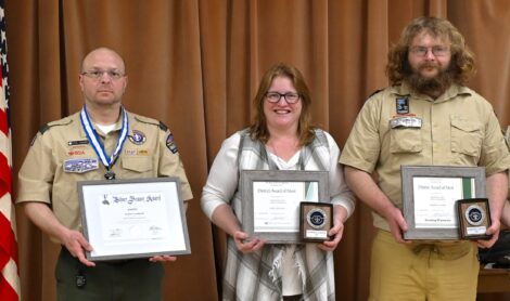
Chief Cornplanter Council holds volunteer recognition dinner
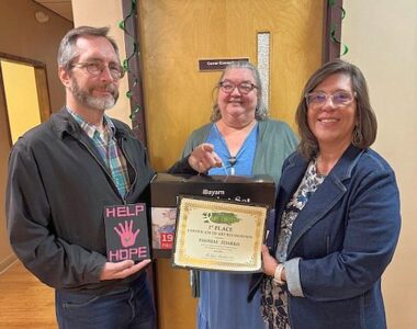
Affiliates of Journey Health System’s art contest focus on mental health
Briefs
Bridge league winners announced Monday evening at the YMCA, Richard Woodruff and Russ Kelley came in first with ...
Attention to details
Hospice planning Summer Wonders Raffle
Hospice of Warren County is excited to announce their Summer Wonders Raffle. Residents can take a chance on ...